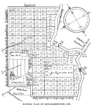
Durham, Maine lot and range map
Title
Durham, Maine lot and range map
Description
Arranged in a grid-like pattern, with the Androscoggin River on the right, this 1766 “lot and range” map of Royalsborough—incorporated as Durham, Maine, in 1789—clearly shows the narrow “intervale” lots bordering the River’s western bank. As in other towns throughout the valley, these fertile and oft-flooded parcels were much sought after by the first white settlers.
Identifier
rivers-journey-16

