The Great River and Its Valley
The 3,400 square miles that make up the Androscoggin basin—the river and its surrounding watershed—were formed over millions of years, with the landscape we see today bearing the marks of the closing stages of the last ice age, which ended some 12-15,000 years ago. The geologic theory behind the formation of the Androscoggin River valley therefore has much to do with the melting and retreat of the great glaciers that once covered northern New England with a mile-thick coating of ice. According to one theory, the retreating glaciers left a chain of lakes from the Maine coast near Brunswick to the Canadian border where present-day New Hampshire and Maine meet. Erosion from higher elevations caused many of the smaller lakes to fill up with sediment; eventually, a river channel formed in these formerly wide but shallow water bodies, leaving behind broad areas of rich alluvial soil in the bottom lands—called “intervales” by New Englanders. Today, many of these low lying intervales along the Androscoggin contain some of the best farmland remaining in western and southern Maine.
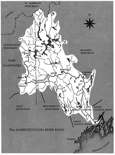
A map of the Androscoggin River watershed. Though one of the largest rivers in Maine, the Androscoggin is unusual because it joins with the Kennebec River at Merrymeeting Bay (below Brunswick), rather than emptying directly into the Atlantic.
A River’s Journey to the Sea
The northernmost sources of the Androscoggin lie nearly 3,500 feet up on the sides of the Border Mountains on the international boundary between the United States and Canada. However, the Androscoggin, proper, starts at the confluence of the outflow stream from Umbagog Lake—the lowest of several vast bodies of water in the Rangeley Lakes chain—and the Magalloway River, whose several branches extend far to the north. Here, at an elevation of some 1200 feet above sea level in northeastern New Hampshire, the Androscoggin passes through Errol Dam (one of over twenty flood-control or hydropower dams on the waterway) and then through the famous “Thirteen Mile Woods,” a winding, relatively calm stretch of water whose heavily forested shorelines are now protected by conservation easements. Entering the Pontook Basin, the river valley broadens, with pastures and cultivated land much in evidence. After several miles of “fast water,” the River approaches the City of Berlin, where it drops nearly three hundred feet in a distance of about two miles—what many have referred to as the “real upper falls of the Androscoggin River.” At Gorham, the next town downriver, the Androscoggin turns eastward from its southerly course and runs another twenty miles past some of the highest peaks in the Appalachian Mountains—crossing the state line into Maine—to the town of Bethel.
Near Bethel, the Androscoggin widens and turns northeasterly as several smaller rivers, including the Wild, Sunday, and Bear, add their waters to the mixture. A very gradual drop in elevation occurs between Bethel and Rumford, where the Androscoggin makes one of the most spectacular leaps along its course, dropping over 170 feet in three falls spread out over a mile. Making a U-turn and heading southeast again, the River passes between the towns of Dixfield and Peru, where, at an elevation of 416 feet above the sea, the Webb River enters from the north. Mountains of lower elevation than those at the Maine/New Hampshire border combine with intervales to produce a scene that is now more pastoral than primitive. At the huge intervale of Canton Point, once one of the largest plots cultivated by Native Americans in New England, the Androscoggin makes a sharp turn and flows through Jay and Livermore Falls, two industrial towns built where the River drops over several major waterfalls.
Below Livermore Falls, the Androscoggin valley widens considerably and the River’s downward flow become more gradual. Below the towns of Leeds and Turner, the River enters a man-made lake created when Gulf Island Dam—the last major dam built on the Androscoggin—was constructed in the mid-1920s. For the next dozen miles, the River flows between the twin cities of Auburn and Lewiston. Just before reaching the “Great Falls,” much of the Androscoggin is diverted by canal through Lewiston, once a bustling center of textile manufacturing. After receiving the waters of the Little Androscoggin at Auburn, the Androscoggin continues its journey to the next series of rapids at Lisbon Falls. Four miles beyond the bottom of Lisbon Falls Rapids, the River enters Brunswick, the oldest town in the valley. After swinging to the east and dropping over a final series of falls, the Androscoggin flows onward for another six miles until it empties into Merrymeeting Bay. Here, the waters of the Androscoggin (said to average 4.19 billion gallons entering the Bay each day) mix with those of the Kennebec and travel seventeen miles due south, past the City of Bath, until finally flowing into Atlantic where the ill-fated Popham Colony was established as New England’s first English Colony in 1607.
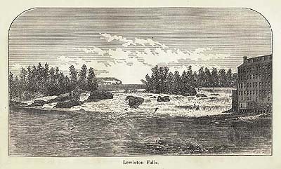
Among the larger rivers in New England, the Androscoggin is by far the most unnavigable by vessels of any size, which explains why it was explored and permanently settled by white people later than other rivers in the region—and, more significantly, why it became so heavily industrialized. This view of the falls between Lewiston and Auburn is taken from Walter Wells' 1869 volume, The Water Power of Maine.
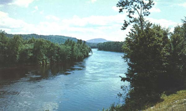
Between the many waterfalls on the Androscoggin are numerous broad and calm stretches of water, which have become increasingly popular with modern-day canoeists. This segment flows through the picturesque countryside of North Bethel.
Major Rivers and Streams in the Androscoggin Watershed
Alder River, Bear River, Black Brook, Clear Stream, Concord River, Cupsuptic River, Dead Cambridge River, Dead Diamond River, Dead River, Ellis River, Kennebago River, Little Androscoggin River, Little River, Magalloway River, Martin Stream, Nezinscot River, Peabody River, Pleasant River, Rangeley River, Rapid River, Sabattus River, Sawyer Brook, Seven Mile Stream, Sunday River, Swift River, Swift Cambridge River, Swift Diamond River, Webb River, Wild River


